Alte Geodatensuche Niedersachsen
Hydrological Basins in Africa (Sample record, please remove!)
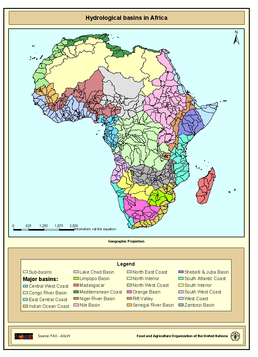
Major hydrological basins and their sub-basins. This dataset divides the African continent according to its hydrological characteristics.
The dataset consists of the following information:- numerical code and name of the major basin (MAJ_BAS and MAJ_NAME); - area of the major basin in square km (MAJ_AREA); - numerical code and name of the sub-basin (SUB_BAS and SUB_NAME); - area of the sub-basin in square km (SUB_AREA); - numerical code of the sub-basin towards which the sub-basin flows (TO_SUBBAS) (the codes -888 and -999 have been assigned respectively to internal sub-basins and to sub-basins draining into the sea)
Simple
- Datum (Erstellung)
- 2000-07-19T14:45:00
- Ausgabe
-
First
- Präsentationsform
- Digitale Karte
- Zweck
-
This dataset is developed as part of a GIS-based information system on water resources for the African continent. It has been published in the framework of the AQUASTAT - programme of the Land and Water Division of the Food and Agriculture Organization of the United Nations, as part of FAO Land and Water Digital Media Series #13: "Atlas of Water Resources and Irrigation in Africa".
For a wider distribution and to support other projects at FAO this map is also distributed in a DVD as part of a publication entitled: "Jenness, J.; Dooley, J.; Aguilar-Manjarrez, J.; Riva, C. African Water Resource Database. GIS-based tools for inland aquatic resource management. 2. Technical manual and workbook. CIFA Technical Paper. No. 33, Part 2. Rome, FAO. 2007. 308 p."
- Bearbeitungsstatus
- Abgeschlossen
- Überarbeitungsintervall
- Bei Bedarf
- Thema
-
-
watersheds
-
river basins
-
water resources
-
hydrology
-
AQUASTAT
-
AWRD
-
- Ort
-
-
Africa
-
- Räumliche Darstellungsart
- Vektor
- Massstabszahl
- 5000000
- Sprache
-
eng
- Zeichensatz
- Utf8
- Thematik
-
- Binnengewässer
- Anfangszeitpunkt
- 2006-01-01T04:29:00
- Endzeitpunkt
- 2008-01-08T04:29:00
))
- Zusatzinformation
-
You can customize the template to suit your needs. You can add and remove fields and fill out default information (e.g. contact details). Fields you can not change in the default view may be accessible in the more comprehensive (and more complex) advanced view. You can even use the XML editor to create custom structures, but they have to be validated by the system, so know what you do :-)
- Identifikator des Referenzsystems
- WGS 1984
Struktur der räumlichen Daten
- Abgabeformat
-
-
ShapeFile
(
Grass Version 6.1
)
-
ShapeFile
(
Grass Version 6.1
)
- Online
-
Online link to the 'Water Resources and Irrigation in Africa'- website
(
WWW:LINK-1.0-http--link
)
Online link to the 'Water Resources and Irrigation in Africa'- website
- Online
-
basins.zip
(
WWW:DOWNLOAD-1.0-http--download
)
Hydrological basins in Africa (Shapefile Format)
- Online
-
GEONETWORK:basins_296
(
OGC:WMS
)
Hydrological basins in Africa
- Bezugsebene
- Datenbestand
- Erläuterung
-
The linework of the map is obtained by delineating drainage basin boundaries from an hydrologically corrected digital elevation model with a resolution of 1 * 1 km.
- Metadatensatzidentifikator
- da165110-88fd-11da-a88f-000d939bc5d8 XML
- Sprache
-
eng
- Zeichensatz
- Utf8
- Datum
- 2007-11-06T12:13:00
- Bezeichnung des Metadatenstandards
-
ISO 19115:2003/19139
- Version des Metadatenstandards
-
1.0