 Alte Geodatensuche Niedersachsen
Wadden Sea National Park of Lower Saxony
Type of resources
Available actions
Topics
Keywords
Contact for the resource
Provided by
Years
Representation types
Update frequencies
status
Service types
Scale
-
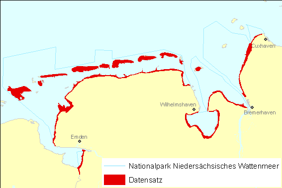
Biotoptypenentwicklung im Nationalpark Niedersächsisches Wattenmeer 1991-1997. Development of biotope types in the Wadden Sea National Park of Lower Saxony 1991-1997.
-
Biotoptypen terrestrischer Bereiche im Nationalpark Niedersächsisches Wattenmeer 1997. Die Kartierung der Biotoptypen erfolgte durch spiegelstereoskopische Interpretation von CIR-Luftbildern. Die Befliegung fand am 21.08.1997 statt. Biotope types of terrestrial areas in the Wadden Sea National Park of Lower Saxony 1997. The mapping of biotope types was conducted by stereoscopic interpretation of CIR aerial images. The aerial flight took place at the 21.08.1997.
-
Biotoptypen terrestrischer Bereiche im Nationalpark Niedersächsisches Wattenmeer 1991. Die Kartierung der Biotoptypen erfolgte durch Interpretation von CIR-Luftbildern. Die Befliegung fand am 21.08.1991 statt. Biotope types of terrestrial areas in the Wadden Sea National Park of Lower Saxony 1991. The mapping of biotope types was conducted by interpretation of CIR aerial images. The aerial flight took place at the 21.08.1991.
-
Die Kartierung der Habitate erfolgte durch Klassifizierung von digitalen CIR-Luftbildern mit GRASS-GIS und über Geländearbeit. Die digitalen Befliegungen fanden 2002 (Kameratyp HRSC-AX) und 2003 (Kameratyp DMC) statt. Die Klassifikation und die Geländearbeit erfolgte 2004. Zur Kartierung von Salzwiesen, Dünen und Grünland wurde ein Schlüssel aus dem "Trilateral Monitoring And Assessment Program" angewendet. The habitat types were identified by processing digital aerial images with GRASS-GIS and through field work. The aerial flights took place in 2002 (camera type HRSC-AX) and 2003 (camera type DMC). For the classification of saltmarshes, dunes and antropogenic grassland a key has been used, which was developed in the "Trilateral Monitoring And Assessment Program" (TMAP).
-
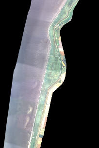
Digitales echtfarb Orthofotomosaik - Kachel 2_02. Aufgenommen mit dem Kamerasystem DMC während der Befliegung des Niedersächsischen Wattenmeeres 2003. Datentiefe 16-bit, Bodenpixelauflösung 32cm. Referenzsystem Gauss-Krüger Zone 3. Digital true colour orthoimage mosaic - tile 2_02, recorded during the aerial flight 2003. Colour depth 16-bit, ground resolution 32cm. Reference system Gauss-Krüger zone 3.
-
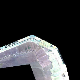
Digitales echtfarb Orthofotomosaik - Kachel 11_02. Aufgenommen mit dem Kamerasystem DMC während der Befliegung des Niedersächsischen Wattenmeeres 2003. Datentiefe 16-bit, Bodenpixelauflösung 32cm. Referenzsystem Gauss-Krüger Zone 3. Digital true colour orthoimage mosaic - tile 11_02, recorded during the aerial flight 2003. Colour depth 16-bit, ground resolution 32cm. Reference system Gauss-Krüger zone 3.
-
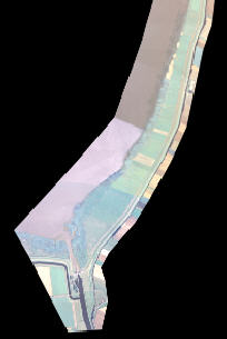
Digitales echtfarb Orthofotomosaik - Kachel 3_02. Aufgenommen mit dem Kamerasystem DMC während der Befliegung des Niedersächsischen Wattenmeeres 2003. Datentiefe 16-bit, Bodenpixelauflösung 32cm. Referenzsystem Gauss-Krüger Zone 3. Digital true colour orthoimage mosaic - tile 3_02, recorded during the aerial flight 2003. Colour depth 16-bit, ground resolution 32cm. Reference system Gauss-Krüger zone 3.
-
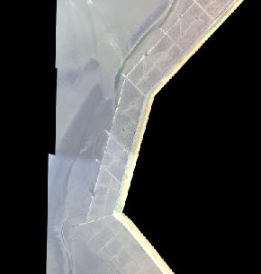
Digitales echtfarb Orthofotomosaik - Kachel 1_05. Aufgenommen mit dem Kamerasystem DMC während der Befliegung des Niedersächsischen Wattenmeeres 2003. Datentiefe 16-bit, Bodenpixelauflösung 32cm. Referenzsystem Gauss-Krüger Zone 3. Digital true colour orthoimage mosaic - tile 1_05, recorded during the aerial flight 2003. Colour depth 16-bit, ground resolution 32cm. Reference system Gauss-Krüger zone 3.
-
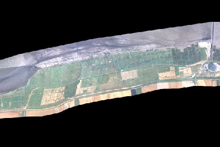
Digitales echtfarb Orthofotomosaik - Kachel 5_02. Aufgenommen mit dem Kamerasystem DMC während der Befliegung des Niedersächsischen Wattenmeeres 2003. Datentiefe 16-bit, Bodenpixelauflösung 32cm. Referenzsystem Gauss-Krüger Zone 3. Digital true colour orthoimage mosaic - tile 5_02, recorded during the aerial flight 2003. Colour depth 16-bit, ground resolution 32cm. Reference system Gauss-Krüger zone 3.